


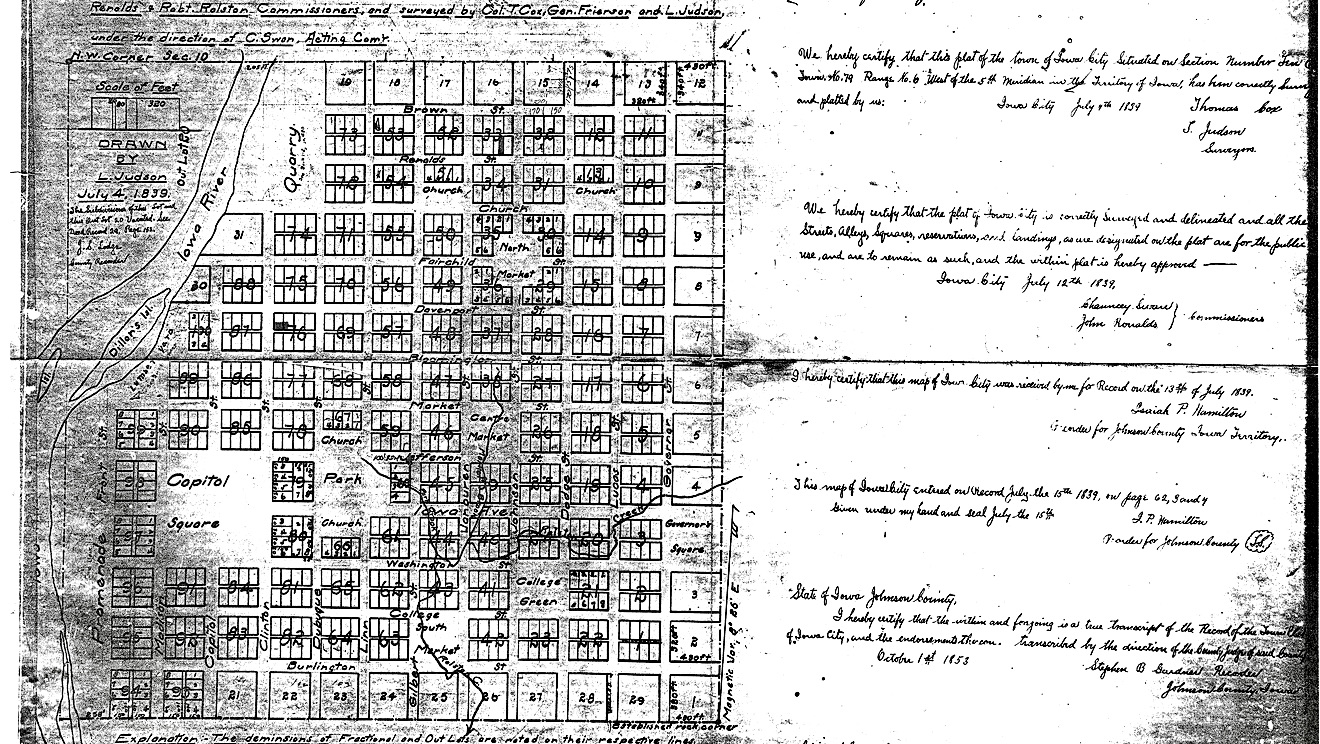
Under U.S. law, when a new Territory was established in the west, that territorial government was allowed to choose a full section of land – one square mile or 640 acres – to establish its capital. As we’ve told you elsewhere, in May 1839 – Chauncey Swan and his companions staked out an uncharted piece of wilderness located on the Iowa River – legally called Section 10 – Township 79 North, Range 6 – West 5th Principal Meridian in Johnson County. By July 4, 1839, that piece of land – one square mile – had been surveyed by Thomas Cox and John Frierson, and drawn out by Leander (L.) Judson on the maps you see below.


Click here to read about early Iowa City maps.
The Original Town Plat of Iowa City, as it was laid out by Leander (L.) Judson, was one square mile (640 acres) of land – with 100 surveyed blocks, 31 out lot blocks, two public squares, three market squares, two public parks and reserves for churches and a school. At the center of the city was “Capitol Square” – the equivalent of four city blocks located on a high overlooking a promenade that bordered along the east bank of the Iowa River.
Each of the 100 city blocks measured approximately 2.35 acres each (320 ft x 320 ft) – with each block sectioned into eight lots measuring 80 x 140 feet. A square-block municipal park was sited north of Iowa Avenue between Dubuque and Linn Streets. Reserves were also set aside for churches and a school facing the park along Iowa Avenue (Block 66), Jefferson Street (Block 67) and Dubuque Street (Block 60). Three market squares were situated along a north-south diagonal line extending from the intersection of Burlington and Gilbert Streets to the intersection of Johnson and Fairchild Streets. The church reserves were eventually granted to four denominations and still serve three churches some 175 years later.
On this page, allow me take Judson’s map and give you few facts about how we, in Iowa City, ended up with the street names we have at our city’s center. As you’ll see, the story has an interesting mix of answers. So, let’s start here:


With six exceptions, the twenty-four streets of Iowa City – which run either east and west (12) or north and south (12) – were designated to be 80 feet wide. The exceptions were Iowa Avenue (120 feet wide) and Washington, Jefferson, Capitol, and Madison (100 feet wide). The 12 north/south streets from west to east are named – Front, Madison, Capitol, Clinton, Dubuque, Linn, Gilbert, Van Buren, Johnson, Dodge, Lucas, and Governor. The 12 east/west streets from north to south are named – Brown, Ronalds, Church, Fairchild, Davenport, Bloomington, Market, Jefferson, Iowa (Avenue), Washington, College, and Burlington.
View this 1839 map in comparison to later maps such as 1854, 1868, 1892, and more.


As you know, some cities designate their streets by calling one direction by names and the other direction by numbers. An example – Main Street, Walker Street, etc. running north and south, while 1st Street, 2nd Street, etc. run east and west. Other cities choose to call one direction – streets, and the other direction – avenues. But, our city fathers in Iowa City chose to ignore that process, designating all 24 streets by using names based on seven different themes.
So now, let’s explore those seven themes – one set at a time. You might want to refer back to this map (above) to see where each street is located. We’ve used 7 different colors to help you identify each theme – Red, Blue, Green, Light Blue, Orange, Yellow, and Purple.


Despite the way early maps of Iowa City might appear, today’s Pentacrest – called Capitol Square in 1839 – was and still is the actual “center” of Iowa City – with all streets in the oldest part of town being numbered and assigned East/West or North/South designation based on their relationship to the Old Stone Capitol. The maps above might help here. So, the “10 Block” surrounds Old Capitol – with the 100 North addresses starting north of Iowa Avenue, while the 100 South addresses start just south of Iowa. The same is true with east/west streets – the 100 East numbers are east of Capitol Street, while the 100 West addresses are west of Capitol. Got it?


An example would be Phillips Hall (top above) – which is across Clinton Street from Old Capitol. This university building is on the 100 block of North Clinton Street – while Iowa Book & Supply (bottom above) – just across Iowa Avenue – has a 100 South Clinton Street address.


Now, for the East/West dividing line – Capitol Street – we find that the main entrance to the Old Capitol Town Center (above left) is at the 100 Block of East Washington Street, while just one block away, the Seamans Center for Engineering Arts (above right) is in the 100 Block of West Washington. This will, many times, cause confusion with most Iowa Citians – believing any street with the word West in it must be located on the west side of the Iowa River. But not so. You see, in 1839, the west side of Iowa City was on the east side of the river! (M-0136)

Now that we have the two most important names covered – Iowa and Capitol – let’s move on to our next theme…


Keep in mind, in 1839, there were only eight choices when picking a U.S. President to honor with a street name. Since Adams Street would not be enough to identify which President Adams, and Jackson – whose presidency had just ended – was a very controversial figure – we’re now down to five names. That leaves us with George Washington (check), Thomas Jefferson (check), James Madison (check), and then, skipping over to the current President, Martin Van Buren. I guess the question we’ll never have answered is why James Monroe was left out. But, I’m happy to report that our fifth president was finally given a street to call his own on the west side of the river – but not until well into the 20th century!


In 1839, Johnson County was far-west country in Iowa Territory. Most of Iowa’s citizens lived on the banks of the Mississippi River in small frontier towns that had all been established less than 10 years earlier. Our city fathers chose four of those cities for street names: Dubuque, of course, is at the top of the list – being Iowa’s oldest community – first established in 1832 near Julien Dubuque’s lead mines. Burlington (1833), makes the list because it was still the Territorial capital (1837-1840), and to not give a tip of the hat to the present capital city would make those legislators still living there pretty hot under the collar. Quite honestly, many were already tee’d off because Governor Lucas had decided to start a new Iowa capital in a more centrally-located place. Davenport is the third choice – reflecting the booming river town (1836) that was springing up across the Mississippi from Ft. Armstrong (Rock Island). Finally, Bloomington was the most obvious choice, because practically no one could get to Iowa City in 1839 without taking a steamboat to Bloomington and then following one of the oldest trails leading into Johnson County’s first community – Napoleon. And just to help those of you who haven’t a clue where Bloomington is – just look at a map today and find Muscatine. The town changed its name in 1850. Read more here.
Now, for those who say, wait, Marty, you missed one – Clinton. You are partially right, but Clinton Street was not named for Clinton, Iowa, but for DeWitt Clinton – the New Yorker we’ll discuss later. And just for the record, in 1839, Clinton was a small dot on the map – a “suburb” of the much larger river community of Lyons. As a matter of fact, Lyons was so big (read more here), it’s a real head-scratcher why it wasn’t included in our original street names! And I’m not Lyon here!


When naming our streets, our city fathers decided to tip their hat to the past Territorial Governor – Henry Dodge – Wisconsin Territory (1845-1848), Robert Lucas – the present Territorial Governor of Iowa (1838-1841), and the future governors of Iowa – Governor Street – with the city laid out in such a way that the broad Iowa Avenue (120 feet wide) would stretch nearly one mile from the Capitol in the west to the new Governors Mansion – on Governor Street – in the east.


Our city fathers – note that our female counterparts or those representing any diversity had no say in this decision at the time – picked five prominent leaders – all from back east, and all with little or no direct connection with Iowa City. Senator John Brown (top left) – an American lawyer and statesman who participated in the formation of the State of Kentucky after the American Revolutionary War, Brown died in 1837 – making it very likely that his name was being remembered in this way. Dr. Oliver Fairchild (no pic) – from Cincinnati, records indicate that Dr. Fairchild donated some important maps to T.S. Parvin who was collecting books and resources for the Iowa Territorial Library in 1838. Read more here. Senator DeWitt Clinton (bottom left) – Clinton was a very popular businessman involved in the development of the Erie Canal. He served as the mayor of New York City (1807-1815), the Governor of New York (1825-1828), and both Clinton and DeWitt, Iowa, and Clinton County are named for him. Read more here about Clinton Street. Dr. Lewis Fields Linn (bottom middle) – Linn was a physician and served as a U.S. Senator from Missouri from 1833-1843. Linn County, Iowa is named for him as well. Finally, Richard M. Johnson (bottom right) – Johnson was Vice President of the United States (1837-1841) when Iowa City was formed, and Johnson County was named for him as well. Interestingly, in 2021, after an extensive search found Johnson to be a rather unworthy candidate for remembrance, the Johnson County Board of Directors re-assigned our county’s name to a more worthy Johnson with deep Iowa City connections – Lulu M. Johnson. Read more here. Since the City of Iowa City has made no such announcement, Johnson Street, technically then, is still named for Richard M. Johnson. A piece of trivia to amaze your friends!


In other posts, we tell you the story of Iowa City’s beginnings. In truth, there were several more important people in this story than the two that our city fathers chose for street names: John Gilbert and John Ronalds. Now granted, in May 1839, John Gilbert had just passed away – so I get the reason for honoring him. And yes, it would be too cheesy for Chauncey Swan to name a street after himself while he’s still living! And I guess Ronalds gets some credit for showing up in May 1839 to help Swan in the selection process! But then there’s Robert Ralston – the commissioner who failed to show that day – almost scuttling Iowa City’s chances to be the new capital. Yet, he still got a big creek named after him. Yikes. My thought is why didn’t they honor Chief Poweshiek in all this? But alas, I realize that the times in which these decisions were made, and the prejudice toward our Native Iowan friends, wouldn’t allow for such things. Yet, here we are nearly 200 years later, and still no major road, park, or building within the Iowa City limits is named for this brave Meskwaki chief who generously gave us his land. This is one of the reasons we’ve helped develop Remembrance Park. Read more here.

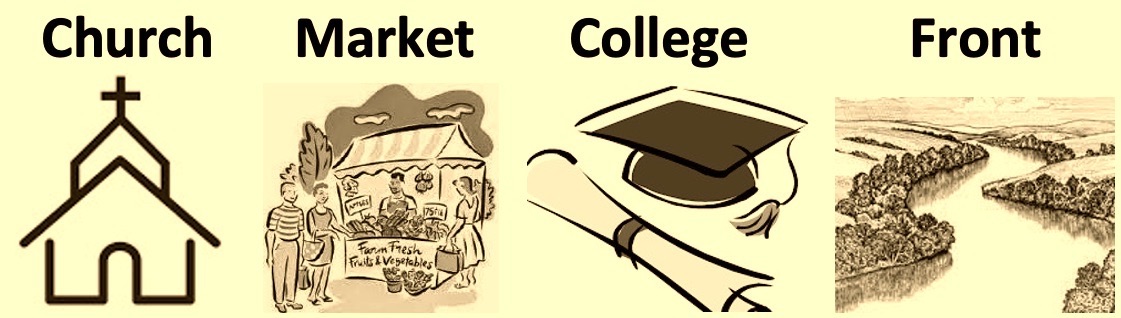
Finally, the city fathers closed the book on street names by choosing four words that best described the activity happening around that particular street. So, here we go…

Church Street – as you can see from the map – the original idea was to have two churches on Church Street. But it never happened – and actually, more churches focused on Iowa Avenue and Jefferson Street than Church. Whoops!

Market Street – of course – took you to the Centre Market. There was a North and South Market on the 1839 map as well. This square never really took off as a market area though Market Street did attract many successful merchants over the years. Centre Market eventually was used for Iowa City’s first two high schools (read more here) and now is owned by Mercy Hospital.

College Street – actually – has nothing to do with the University of Iowa. Originally, there was a plan to build a college for women on this block marked College Square – thus the name College Street. That plan never happened, but in 1862, a very successful women’s academy opened on Jefferson Street – called St. Agatha’s Seminary. Read more here.


Front Street – at the lowest point of the city and down by the riverside – Front was planned on the far west end as the gateway to Iowa City when people arrived in our fair community via steamboat. Front Street and the Promenade (see map) never really got off the ground due to flooding issues and the fact that steamboats never really became a reliable form of transportation. Read more here. Front Street, however, survived for many years – birthing what was called the Rinella Neighborhood – which thrived until the 1920’s. Read more here.
But wait! You thought we were done? There’s two more streets to tell you about…


Very soon after L. Judson’s map was published on July 4, 1839, the city fathers added two additional names to the twenty-four originally listed. If you look carefully at the map (above), you’ll see three un-named streets – one on the south, one to the east, and one on the north. If you look at a map of Iowa City today, you’ll find that there has never been another east-west street built directly north of Brown Street. And, as most Iowa Citians know, that is not the case to the south or to the east. By 1840, land was being purchased in both directions, and soon, numerous new streets were being added. But the first of those streets – that were actually a part of the original one-square mile called Iowa City – were Summit Street to the east, and Court Street to the south.

Court Street – located on the far south edge of Iowa City – just south of Burlington Street – Court got its name from being the street where the newly-appointed Johnson County commissioners decided to secure land for a new county court house. Read more here.


After the surveying and platting of Iowa City was completed and Judson’s map drawn up, the good people of Iowa City – in the summer of 1839 – placed a large limestone marker at the very southeastern corner of the city – today’s 331 Summit Street – the key starting point for the 1839 survey.


(P-0375) Today, that 1839 Limestone Marker is the oldest remaining structure in Johnson County!
Click here to read more about this Johnson County remembrance marker and many others.

So there you have it. The twenty-four original streets of Iowa City – plus two late-comers! As you know, many more streets have been added since then – with city expansion going first to the south, then to the east and north, and eventually, west across the Iowa River.
Read more about the early days of Iowa City’s brick streets.

One final tip before we close. Again, the first step in all of this is to remember to pay attention to the ‘direction’ that is attached to the street name. If it says E. Washington, it will be east of Old Capitol and Capitol Street, but if it says W. Washington, it will be west of Old Capitol and Capitol Street – but still on the east side of the river! And on north/south streets, if it says N. Clinton Street, you will be north of Iowa Avenue, but if it says S. Clinton, you need to stay south of Iowa Avenue.
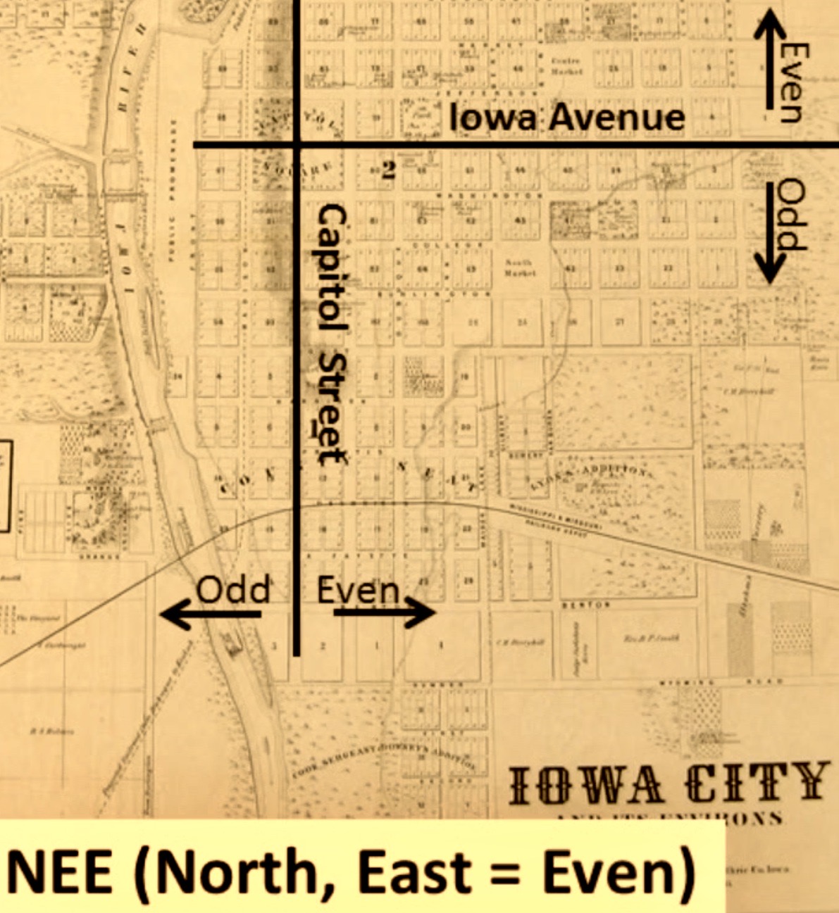

Now comes the fun part. The next time you are looking for an address and you’ve found your street, the best way to find an exact location is to use Thomas Schulein’s NEE system (see above). NEE – simply helps you remember that all of the addresses on the north (N) or east (E) sides of any street will be even (E) numbers. So 722 E. College Street (even) will be on the north side of the street, while 25 W. Burlington Street (odd) will be on the south. Going the other direction, 304 S. Dubuque Street (even) will be on the east side of the street, while 287 N. Linn Street (odd) will be on the west. Got it?


Did you know that on May 27, 2021 – the Iowa City Downtown Historic District was designated on the National Register of Historic Places? Thanks for journeying with us! Now, go out and enjoy our city!


(M-0155) & (M0156) Enjoy these two “Iowa City” license plates from OIH collection!

DYK-May 1, 2023

May 27, 2021 – The Iowa City Downtown Historic District is designated on the National Register of Historic Places.
Kudos to the amazing resources below for the many quotes, photographs, etc. used on this page.


Brown Street Historic District, Wikipedia
John Brown (Kentucky politician), Wikipedia
The Name and Family of Fairchild, T.M. Fairchild of Iowa City, Iowa, Mercer Publishing, 1944
Richard Mentor Johnson, Wikipedia
Click here to go on to the next section…
Click here for a complete INDEX of Our Iowa Heritage stories…