


In 1800, Napoleon Bonaparte sought to create a great French empire in the New World, with the center of that empire being the nation of Hispaniola – located in present-day Haiti. Napoleon envisioned that the vast Mississippi River Valley, called Louisiana, could easily become a major trade center for his emerging empire, shipping food and supplies from the north into Central America. The Louisiana region had been named for French King Louis XIV (pictured below) and covered 530 million acres – 828,000 sq miles – from the Mississippi River to the Rocky Mountains, between Canada and the Gulf of Mexico.


The only problem with Napoleon’s grand scheme was that Hispaniola was in the midst of a slave revolt, and this rebellion had to be put down before he could move forward with his expansion plans. In an attempt to address the problem, Napoleon sent in a large army, and while there were considerable French victories on the battlefield, many soldiers also died from disease. Due to these heavy losses, the French dictator began second guessing his vision, wondering if his dream of a large French empire in the New World was truly feasible.


Meanwhile, when Thomas Jefferson became President of the United States (1801), Jefferson and his private secretary, Army Captain Meriwether Lewis, began to plan an expedition to explore this uncharted West called Louisiana. The President, in direct competition with not only Napoleon, but England and Spain as well, hoped to be the first to establish a land-and-water route from the Atlantic to the Pacific, making peace treaties with Native tribes and gathering scientific information along the way. Early in 1803, Congress approved Jefferson’s grand ideas and appropriated funding for this expansive expedition.


Back in France, with the dream of Hispaniola quickly fading, Napoleon had very little use for Louisiana, but did need an influx of cash. War with England was on the horizon and Napoleon knew he had to find a way to fund it. Conveniently, James Monroe and Robert Livingston were in town, negotiating on the possible purchase of New Orleans. It was in the midst of those negotiations – the U.S. was prepared to pay up to $10 million for New Orleans – when Napoleon – on April 10, 1803 – suddenly offered all of Louisiana for the tidy sum of $15 million. At first, the two Americans were hesitant at such a large purchase, but both of them knew enough about Jefferson’s wide-eyed expansion ideas to say ‘yes’ to the offer.

And what an offer it was. On April 30, 1803, the United States acquired both New Orleans and the land called Louisiana – which would someday make up all or part of fifteen states! Immediately, this purchase doubled the size of the United States, while also guaranteeing free navigation of the entire Mississippi River valley! Monroe and Livingston (below left) returned to Washington D.C. elated with the good news, and now, Jefferson’s planned survey of the West suddenly took on a whole new level of importance.
On March 9 and 10, 1804, two ceremonies, commemorated as Three Flags Day, were conducted in St. Louis, 1) to transfer ownership of Upper Louisiana from Spain to France, and 2) transfer the entire region from France to the United States. From March 10 to September 30, 1804, Upper Louisiana – of which Iowa was part of – was supervised as a military district, under its first civil commandant, Amos Stoddard, who was appointed by the War Department.


In the meantime, Jefferson named Meriwether Lewis (1774-1809) as head of the Army Corps of Discovery, calling him “brave, prudent, habituated to the woods and familiar with Native manners and character.” Captain Lewis in turn named Lieutenant William Clark (1770-1838) to serve as co-captain of the expedition. In this role, Clark was assigned to draw maps and sketches, observing and recording flora, fauna, and Native life, along the way.


(M-0132) The Lewis & Clark team departed from camp near St. Louis on May 14, 1804, traveling about 8,000 miles on their journey. The explorers canoed their way up the Missouri and Jefferson Rivers, crossed the Rocky Mountains – with the help of the Native guide Sacajawea – then followed the Clearwater, Snake, and Columbia Rivers down to the Pacific Ocean. In 2000, the U.S. Mint released a golden dollar coin (see above) celebrating this brave Native American woman and her contribution to the success of this mission.
On the return trip, the party split up to cover more ground. Lewis went down the Marias River, and Clark descended the Yellowstone. The expedition was greeted by cheering crowds as they returned to St. Louis on September 23, 1806.


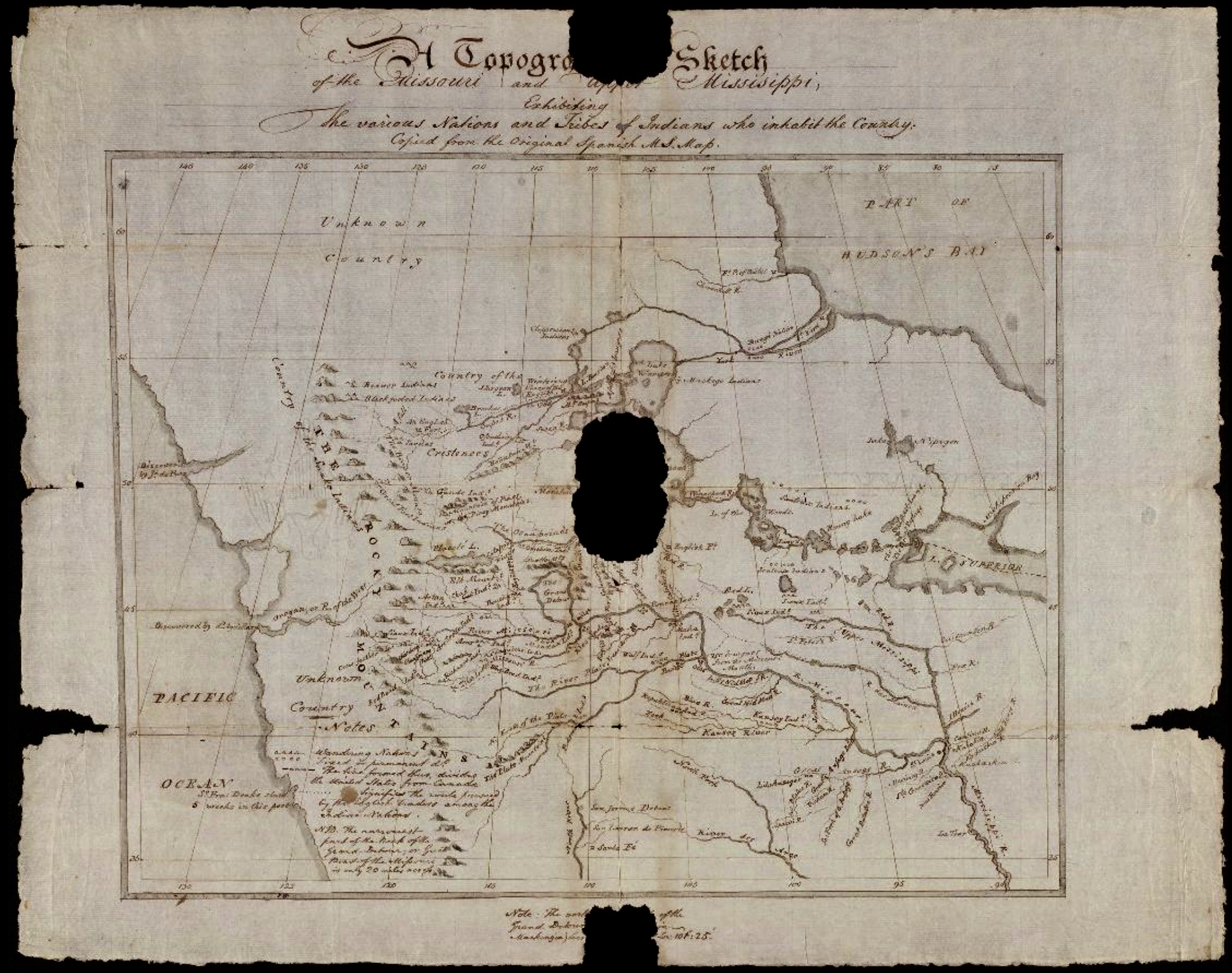
When Lewis & Clark set out to explore the Louisiana Purchase (1804), they had several crude maps to help plot out their journey. The most accurate was the one pictured above: The Upper Mississippi and Missouri produced in 1795 by Antoine Pierre Soulard – created for Spanish officials in St. Louis nearly a decade before Lewis and Clark made their journey. Below is a revised version of Soulard’s map created by Meriwether Lewis at the end of their journey in 1806.


(S-0012) (S-0013) (S-0014) (S-0015) The Louisiana Purchase Exposition, informally known as the St. Louis World’s Fair, was an international exposition held in St. Louis from April 30 to December 1, 1904. Local, state, and federal funds totaling $15 million were used to finance the event. More than 60 countries and 43 of the 45 American states maintained exhibition spaces at the fair, which was attended by nearly 19.7 million people.


(M-0004) In our collection are a Souvenir Postcard and a Stereoscope Picture Card from the 1904 St. Louis World’s Fair. Both feature the State of Iowa Building on the fair grounds. On the back side of the Picture Card, we find a delightful informational piece that describes the Iowa State Building . . . “one of the most imposing of the state buildings” at the fair. In 1944, Judy Garland, of Wizard of Oz fame, appeared in MGM’s big musical hit that was set in St. Louis during the 1904 World’s Fair.


(C-0012, C-0012A) In 1954, this commemorative stamp celebrated the 150th Anniversary of the Lewis & Clark Expedition.


A suitable and permanent public memorial to the men who made possible the western territorial expansion of the United States, particularly President Jefferson, his aides Livingston and Monroe, the great explorers, Lewis and Clark, and the hardy hunters, trappers, frontiersmen and pioneers who contributed to the territorial expansion and development of these United States, and thereby to bring before the public of this and future generations the history of our development and induce familiarity with the patriotic accomplishments of these great builders of our country.


In November 1944, Smith discussed the design of the memorial, asserting that the memorial should be “transcending in spiritual and aesthetic values”, best represented by “one central feature: a single shaft, a building, an arch, or something else that would symbolize American culture and civilization. In 1953, at the Louisiana Purchase sesquicentennial celebration, the arch was still just a dream.


Ten years later, on February 12, 1963, construction of the arch began, being completed two and half years later, on October 28, 1965. The Gateway Arch is a 630-foot monument, clad in stainless steel and built in the form of a weighted catenary arch, it is the world’s tallest arch, and the tallest man-made monument in the Western Hemisphere. Built as a monument to the Louisiana Purchase and the westward expansion of the United States, the Arch, commonly referred to as “The Gateway to the West,” has become an internationally recognized symbol of St. Louis, as well as a popular tourist destination.

On a personal note, some of my favorite childhood memories include summer road trips to St. Louis to see the Cardinals play in the first Busch Stadium (torn down in 1966), take in a Broadway show at Muny Opera in Forest Park, and tour the city. I recall vividly, the annual progress we saw on the Arch as we drove into the city during those steamy summers of 1963, 64 and 65.


Speaking of memorials, the only man to die on the dangerous Lewis & Clark journey was Sergeant Charles Floyd. Floyd took ill at the end of July 1804 and died on August 20. The expedition held a funeral and buried Floyd on a bluff overlooking the Missouri River – today, just outside Sioux City, Iowa – they named it Floyd’s Bluff in his honor.


(S-0020) In 2003, the 200th Anniversary of the Signing of the Louisiana Purchase was celebrated, followed by a series of three stamps issued the following year (2004). (C-0014) (C-0015) (P-0178)


Without a doubt, the $15 million spent to purchase the Louisiana Territory in 1803 has turned out to be a pretty wise investment for the United States. And without the brave work of Lewis and Clark, and their Army Corps of Discovery, who knows how things might have turned out for those of us living in the original land of Louisiana.
Plus, think of it this way…without all this, I’d probably be writing this history lesson in French from some town in North Hispaniola!


April 30, 1803 – The Louisiana Purchase agreement between France and the United States is signed in Paris. A Day-by-Day Calendar of Historical Events In Iowa, William J. Petersen, State Historical Society of Iowa, 1946, p 41
March 10, 1804 – Captain Amos Stoddard represents Napoleon and also the United States in the transfer of Upper Louisiana to the United States. The Louisiana Purchase is now complete. A Day-by-Day Calendar of Historical Events In Iowa, William J. Petersen, State Historical Society of Iowa, 1946, p 28, (2)
May 14, 1804 – Lewis & Clark team depart from camp near St. Louis – traveling about 8,000 miles on their journey into the Louisiana Purchase. A Day-by-Day Calendar of Historical Events In Iowa, William J. Petersen, State Historical Society of Iowa, 1946, p 47.
April 30, 1904 – The Louisiana Purchase Exposition, informally known as the St. Louis World’s Fair, opens in St. Louis.
Kudos to the amazing resources below for the many quotes, photographs, etc. used on this page.
Soulard’s Map of 1795, Meriwether Lewis, Yale University Library
Click here to go on to the next section…
Click here for a complete INDEX of Our Iowa Heritage stories…