


Since its inception as part of the United States (1803), the Louisiana Purchase, the land of Iowa had always been part of something else:
- 1803 – Louisiana Territory – Northern Section.
- 1812 – Missouri Territory.
- 1821 – Unorganized Territory.
- 1834 – Michigan Territory.
- 1836 – Wisconsin Territory – Iowa District.
All that changed in 1838, when the new Iowa Territory came into existence.


The whole process began on December 14, 1837, when a petition was sent to the U.S. Congress – asking for the creation of a separate Territory of Iowa west of the Mississippi.

Below is an important 5-page document from U.S. Senate/House of Representative records. In the 25th Congress/2nd Session on February 6, 1838, the proposal of establishing a new U.S. Territory – Iowa – separate from the existing Territory of Wisconsin, is given. These pages record the entire legal transaction within the U.S. Senate and House. (L-0061)


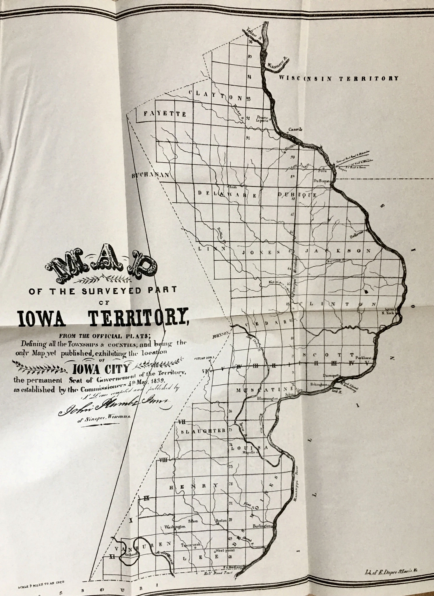
On July 4, 1838, Iowa officially became a separate U.S. Territory, and President Martin Van Buren looked to Ohio, hand-picking Robert Lucas as Iowa’s first Territorial Governor and Superintendent of Indian Affairs. When Governor Lucas arrived in Iowa, later that summer, the Territory (see map below) – which included much of today’s Minnesota and half of the Dakotas – had 22 counties and a population of 23,242. Click here to read more about Robert Lucas.

On November 22, 1838, the Council of the First Legislative Assembly of the Territory of Iowa requested the Secretary of the Territory to submit “The Great Seal of this Territory, with its impression, for inspection.” The submitted seal (see pic above) served until statehood (1846) when the legislature adopted the current Great Seal of the State of Iowa. Read more here.


While Iowa was a U.S. Territory (1838-1846), we had three different Territorial Governors, all appointed by the U.S. President: Robert Lucas (1838-1841) appointed by Martin Van Buren; John Chambers (1841-1845) appointed by John Tyler; and James Clark (1845-1846) appointed by James Polk.


Since Burlington, Iowa had been chosen in 1837 as Wisconsin Territory’s “temporary” capital – replacing Belmont, Wisconsin while a new capitol building was being constructed in Madison City – Governor Lucas announced that the small river town located near the new territory’s southern border would remain the temporary capital until he could arrive in Iowa and “officially” call for a duly-elected Territorial Legislature to be formed. For more on how Iowa City came into being, click here.


Albert Lea’s map of Iowa District in 1835 (above left) shows two counties – Dubuque (north) and Des Moines (south). By 1840 (above right), on a map by J.H. Colton, the surveyed section of Iowa Territory now indicates nineteen counties with more planned.


In the 1948 reprint of John Plumbe‘s Sketches of Iowa and Wisconsin (1839), William J. Peterson – Superintendent of the State Historical Society of Iowa – wrote this about this new Territory called Iowa…
(In) a space of four years from 1836 to 1840, the “Iowa District” had quadrupled in population, catapulting from 10,531 to 43,112. Such sensational growth was not disregarded in the East, where the seaboard states saw their population being siphoned off by the lure of rich, cheap, and abundant land.


In my office hangs a very rare survey map of Iowa Territory dating back to about 1845. As Iowa was opening up to new settlers from the east, a public survey map like this was very important in charting out land plats. This surveyor’s map indicates the progression. Click here to read more about the surveying process.


Here’s the Boller farmstead as surveyed in 1845 – Washington Township of Johnson County. Read more here.


February 6, 1838 – The U.S. Congress Committee on the Territories introduces a bill to divide the Territory of Wisconsin and establish the Territory of Iowa. A Day-by-Day Calendar of Historical Events In Iowa, William J. Petersen, State Historical Society of Iowa, 1946, p 18
November 22, 1838 – The Council of the First Legislative Assembly of the Territory of Iowa requests the Secretary of the Territory to submit “The Great Seal of this Territory, with its impression, for inspection.”
January 4, 1839– Governor Robert Lucas approves the act adopting the Great Seal of the Territory of Iowa. A Day-by-Day Calendar of Historical Events In Iowa, William J. Petersen, State Historical Society of Iowa, 1946, p 6
July 4, 1838 – Iowa, which had been part of Wisconsin Territory since 1836, officially becomes a separate U.S. Territory, with President Martin Van Buren hand-picking Ohio’s Robert Lucas as Iowa’s first Territorial Governor.
Click here to go on to the next section…
Click here for a complete INDEX of Our Iowa Heritage stories…