


Today, one of the nicest aspects of living in Iowa City is its abundance of recreational activities. According to our city’s website, Iowa City is home to over 50 parks, natural areas, and open spaces, with almost 100 percent (99.4) of Iowa City residents living within one half-mile of open green space.


It’s interesting to look back through our city’s history and see that it’s always been important to have plenty of open space available to its residents. In earlier posts, we’ve discussed how Iowa City’s origin is unique as compared to other cities. Iowa City, you see, from the very beginning, was a planned city – built for an explicit purpose. So in 1839, as city planners laid out one-square mile of Iowa City, you can see from L. Judson’s map (above) that a City Park was an important component. In a later map developed in 1868 (below), you can see the artist’s rendition of that same City Park – located two blocks east of Old Capitol – surrounded by Iowa Avenue on the south, Linn Street on the east, Jefferson Street on the north, and Dubuque Street on the west.


As Iowa City drew ever closer to the turn of the 20th century, controversy about City Park abounded, with the leaders of our fair city facing the hard decisions all growing communities must grapple with. In 1890, forty-three years after its inception, The State University of Iowa was quickly running out of state-owned property. Rumor had it that some in the Iowa State Legislature believed that the state’s university needed to be more centrally-located, just as they had decided in 1857, when they voted to relocate the state capital to Des Moines. So, in 1890, in order to appease the Board of Regents, and to put an end to any such speculation, our city fathers decided to donate City Park to SUI for educational purposes.

As you might imagine, this decision sparked an outrage. Iowa City historian, Irving Weber, gives us some more details…
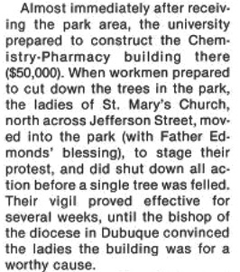


So, Round One went to the city. Some believe that, in order to pacify the church ladies, the city leaders decided to erect a “decorative hexagonal fountain” right in the middle of the intersection of Iowa Avenue and Dubuque Street – see pics below…


Now, let’s turn our attention to the eventual replacement of Iowa City’s first City Park. To do that, I must take you, once again, back to our city’s origins.


In 1840, an early Iowa City pioneer named Walter Butler purchased a large portion of untamed prairie located north of the city – which today includes large portions of property adjacent to the Iowa River in both Iowa City and Coralville. Later that same year, Butler sold some of his property to Walter Terrell, who had a vision to build both a dam and a flour mill just north of town (see pics below).

Click here to read the full story about Walter Terrell and his successful mill business.


When Walter Terrell built his dam & mill (1843), there was an island in the center of the Iowa River. So, Terrell built his dam in two sections. One part was built from the eastern side of the island to the present Dubuque Street side, and the other was built from the island west to what is today, City Park.
The island never had a name and, according to Iowa City historian, Irving Weber, it was always simply called “The Island.” About 75 yards long and 25 yards wide, with a heavy growth of trees; at one point in its history, an attempt was made to establish a beach on The Island, but the two barge-loads of sand quickly sank into the river’s muddy bottom!
The Island was a popular spot for boating, canoeing, swimming and picnicking, and it is said to be the place where “many a lover’s troth was pledged there.” Nearby was Fitzgerald’s Boathouse where one could rent a canoe, paddle over to The Island and enjoy a secluded get-away!


In 1903, the Iowa River flooded again, and this time, Terrell’s daughter – Mary A. Terrell, together with her husband, banker Euclid Sanders, gifted the dam to the University of Iowa’s School of Applied Sciences. The University paid $600 to repair the dam and promised to protect the family from “possible nuisances” caused by development near their home.

June of 2013 (24.90 ft.)
July of 2014 (25.15 ft.)
August of 1993 (28.52 ft.)
June of 2008 (31.53)
Burlington Street Dam and Power Plant. In 1905, the dam was relocated down river (Burlington Street) and became the University’s Power Plant (see below).


In 1906, with the land now cleared, the city purchased 78 acres from the Terrell Estate for $10,000, and Iowa City established City Park that same year. When City Park opened in 1906, access to the new park was limited. One would need to walk or ride in a carriage across the Iowa Avenue Centennial Bridge to get there. But that all changed in 1909.


Back in the day, prior to Polaroid snapshots and phones with cameras, Penny Postcards were the best way for anyone to “take pictures” of places you’ve been. For 1-cent, you could mail a beautiful postcard that had a scenic picture on one side and room for a brief message on the other. Obviously, one of the more popular subjects chosen for postcards in Iowa City was the new City Park. Enjoy some of the scenery…


(P-0202) (P-0309) City Park at night – circa 1915. Click here to see more turn-of-the-century postcards showing recreational fun on the Iowa River…


DYK-September 11, 2023
DYK-September 18, 2023
Kudos to the amazing resources below for the many quotes, photographs, etc. used on this page.

Iowa City – City Park, Think Iowa City
On Iowa, Irving Weber, University of Iowa Press, 1996, pp 61-62
City Park, Iowa City Parks, Laura Hayes, University of Iowa Library
City Park Virtual Tour, City of Iowa City.gov
Click here to go on to the next section…
Click here for a complete INDEX of Our Iowa Heritage stories…